Introduction
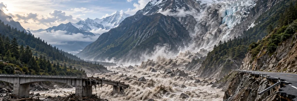
The 26 August 2026 catastrophe in the Nepal and China border region should be understood as a warning about the changing character of Himalayan disaster risk. The available evidence indicates that the initiating event was not a conventional monsoon flood and was not simply the bursting of a known glacial lake. A rapid failure involving rock and glacier ice in the Langtang region transformed into an exceptionally mobile mass flow and flood that moved through the Lende Khola and Trishuli river system, damaging settlements, transport links, hydropower facilities and communication infrastructure over a very large downstream corridor. The United States Geological Survey mapped the debris flow and flood over nearly 100 kilometres, while GFZ reported seismic evidence consistent with a huge mass movement and estimated upper-reach flow velocities of roughly 40 to 50 metres per second.[1][2]
The human consequences remained severe and incompletely resolved more than three weeks later. On 16 September, Reuters reported figures from Nepal’s National Disaster Risk Reduction and Management Authority showing at least 1,399 confirmed deaths and about 5,200 people still unaccounted for, including hundreds of foreign nationals. Many recovered bodies had not yet been identified, illustrating how a geomorphic disaster quickly becomes a prolonged humanitarian, forensic and administrative crisis.[3] These numbers are operational figures rather than final disaster statistics, but they establish the scale of the event and underline why infrastructure policy cannot treat high mountain risk as a narrow engineering question. In Himalayan valleys, roads, hydropower plants, border facilities, settlements, transmission lines, tourism routes and communication systems often occupy the same constrained corridors. A single upstream failure can therefore affect several systems at once.
The scientific description of the initiating mechanism has evolved as satellite, seismic and field evidence has accumulated. USGS initially described a rapid slope failure involving a glacier and noted that it was unclear whether the first movement was a landslide incorporating glacier ice or a glacial collapse. GFZ described a probable hanging-glacier and bedrock break-off, while later analyses have emphasised a mixed rock-ice avalanche and compound cascade. The responsible approach is therefore to preserve uncertainty about the precise initiation sequence while recognising that the downstream transformation into a destructive debris-rich flood is well established.[1][2]
From single hazards to cascading mountain systems
A central conceptual problem in Himalayan planning is the tendency to organise risk by administrative category. Flood agencies focus on river level, glacier programmes focus on glacial lakes, highway engineers focus on slope stability next to roads, dam planners focus on design floods, and disaster authorities focus on evacuation and response. The mountain system does not respect these boundaries. A high-altitude rock failure may entrain glacier ice, generate rapid meltwater, mobilise unconsolidated sediment, block a tributary, destroy a bridge, release further debris when that bridge fails, and then enter a hydropower or settlement corridor. The relevant unit of analysis is therefore the cascade from source to pathway to exposure and then to secondary failures, not the name initially assigned to the event.
This distinction matters because different physical processes impose different loads on infrastructure. Clean-water hydraulic design focuses on discharge, depth and velocity, but debris-rich flows can contain high sediment concentrations, large boulders and timber; they can scour foundations, batter bridge piers, change channel position, block tunnel portals and create temporary dams. When a temporary blockage fails, a second flood pulse may occur even after the first wave has passed. In practical terms, a project may satisfy a conventional flood standard yet remain highly vulnerable to a compound process that changes the river itself. The 2021 Chamoli disaster is a strong Indian example: approximately 27 million cubic metres of rock and glacier ice collapsed from Ronti Peak and transformed into an unusually mobile debris flow that severely damaged two hydropower projects.[9]
Sustainable Himalayan infrastructure should be evaluated against a dynamic catchment, not merely against a static river channel. The assessment should ask what can fail upstream, what material can be entrained, how the channel may change, what structures may become obstructions, and how the failure of one asset can increase the hazard to another. This is a policy inference from documented hazard cascades, not a claim that every Himalayan project faces the same level of risk.
What the August 2026 Nepal event established
The United States Geological Survey described the event as a catastrophic debris flow and flood likely triggered by rapid slope failure involving a glacier in Langtang National Park near the Chinese border. Its rapid mapping found that the flow and flooding travelled approximately 100 kilometres and affected populated areas downstream along the Lende Khola and Trishuli rivers, including the Rasuwagadhi border area. USGS also recorded a second seismic event about three hours later, indicating that the disaster landscape remained active after the initial failure.[1] GFZ independently reported that global seismometers registered a signal equivalent to approximately magnitude 5.2 to 5.7 at 02:52 UTC and concluded that the signal was most probably generated by the mass movement rather than an ordinary tectonic earthquake. Its preliminary reconstruction estimated flow speeds of around 40 to 50 metres per second and described water and debris heights of several tens of metres in places.[2]
These observations change the engineering interpretation of the disaster. The event was not simply a larger version of an ordinary river flood. The movement began high in steep terrain, acquired water and sediment, and propagated as a rapidly evolving mixture of rock, ice, mud and floodwater. Such a process can produce very high impact forces and can enlarge as it moves downstream. It can also erase or relocate the reference geometry on which ordinary hydraulic calculations depend. A design that assumes a stable channel may fail when banks are scoured, debris fills the bed, an obstruction diverts the flow, or an old channel is reoccupied. Consequently, hazard assessment must address both the energy of the incoming flow and the possibility that the valley floor itself will be reworked.
The disaster also demonstrated the importance of infrastructure interdependence. Roads are needed for evacuation and rescue, electricity is needed for communications and pumping, telecommunications are needed to transmit warnings, and hydropower corridors may themselves be exposed to the same flood that disrupts the wider grid. Reuters reported that the event swept away or severely damaged multiple hydropower facilities, after which Nepal stopped electricity exports and India approved temporary power exports of up to 654 megawatts for 18 hours daily until the end of 2026.[19] This is not merely a post-disaster energy story. It shows that resilience planning should test whether critical systems can continue operating when several forms of infrastructure fail together.
The early warning problem was larger than a failed sensor
Nepal already had flood monitoring and public alert arrangements, but the event exposed the limitations of systems that depend mainly on recognising danger after a river has begun to rise. Reporting by The Kathmandu Post, based on official interviews and the sequence of alerts, stated that the ice-rock avalanche occurred at about 8:37 am and that public text alerts were sent at approximately 9:15 am, around 38 minutes later.[4] In a basin where the destructive flow was already moving extremely quickly, this interval left communities close to the source with little usable evacuation time. The same reporting also described the loss of monitoring stations in the upper basin, demonstrating a fundamental design problem: sensors located in the hazard corridor may be among the first assets destroyed.
The World Meteorological Organization’s Early Warnings for All framework is useful because it treats warning as an end-to-end system rather than as a siren or message. Its four pillars are disaster risk knowledge; detection, observation, monitoring, analysis and forecasting; warning dissemination and communication; and preparedness and response capability.[18] The Nepal event reveals why all four matter. A perfectly functioning river gauge cannot warn about a collapse that occurs upstream of the gauge until the flow reaches it. A satellite signal is not enough unless it is interpreted and linked to a decision protocol. A message is not enough unless it reaches the right people in a language and form they understand. A warning that reaches a village is not enough unless residents know where higher ground is and can physically reach it before the hazard arrives.
A useful performance measure is the time remaining after a threatened person receives, understands and acts on a warning. This differs from the time between sensor detection and message transmission. It forces administrators to examine the complete chain of detection delay, scientific interpretation, authorisation, communications, public comprehension, mobility and actual arrival of the hazard. For high-speed mountain cascades, a system that technically sends an alert may still provide almost no actionable lead time.
Redundancy is therefore essential. River gauges, seismic detection, satellite radar, automated cameras, weather stations and community observers perform different functions and should not be treated as substitutes. The most robust arrangement is layered: broad-area remote sensing identifies anomalous change, ground or near-ground instruments provide local confirmation where feasible, downstream gauges track propagation, and communications use multiple channels so that loss of one tower or sensor does not silence the entire system. Local communities also require pre-agreed triggers. If every alert must pass through a long verification chain before evacuation begins, the scientific system may be accurate but the operational system may still fail.
Remote sensing changes what counts as a warning sign
Post-event analysis reported by Nature showed that Sentinel-1 radar imagery contained evidence of movement and acceleration in the glacier-rock system before the collapse. Geophysicist Manoochehr Shirzaei identified a pattern in which the rate of deformation increased before the disaster, although he emphasised that the observations were preliminary and would not, by themselves, have justified a precise prediction of the collapse date.[5] This distinction is critical. Synthetic aperture radar can detect subtle surface displacement across large and inaccessible areas and can operate through cloud, which makes it valuable in monsoon and high-mountain environments. Yet many slopes and glaciers move without failing, while some failures develop too quickly or with signals too subtle for operational forecasting.
The policy opportunity is therefore a tiered screening system rather than a promise of perfect prediction. Regional satellite observations can be used to detect unusual motion or acceleration. Repeated observations can establish whether a trend is persistent. Geomorphologists and glaciologists can then assess whether the moving mass has a plausible failure pathway, whether it contains ice or frozen ground, and whether downstream exposure is high. Only the highest-priority sites may justify expensive local instrumentation. This approach makes remote sensing a risk filter. It also allows limited field resources to be directed to locations where failure would have the greatest consequences.
The unresolved challenge is not merely detecting movement. It is deciding which patterns of movement, acceleration, thermal conditions, meltwater, rainfall, snow loading and geological structure should trigger closer monitoring or evacuation. A practical system must minimise both missed failures and repeated false alarms. This requires large validation datasets containing past failures as well as unstable slopes that did not fail, and it requires social research on how communities respond when alerts are frequent or uncertain.
Climate attribution now has stronger evidence, but causation still requires precision
Scientific interpretation of the event changed materially after the first week. On 17 September 2026, World Weather Attribution released a rapid synthesis examining the climatic and geological conditions associated with the rock-ice avalanche. The analysis concluded that human-caused warming contributed to the conditions that made the disaster more likely by thinning glaciers, raising the freezing level and thawing high-altitude permafrost, while also recognising other possible contributors such as geological structure and long-term damage from the 2015 Nepal earthquake. The study described July and August 2026 as the warmest on record locally and estimated that human influence had added roughly 1.5 degrees Celsius of warming during those months in the collapse region.[6] This is substantially stronger than a general statement that climate change is merely part of the regional background.
Even so, attribution should not be expressed as though one climatic variable mechanically caused the slope to fail at a known moment. World Weather Attribution characterised the disaster as a compound crisis shaped by interacting climatic and geological factors, and the exact initiation mechanics remain under scientific investigation.[6] A useful distinction is between preconditioning and triggering. Long-term warming can thin ice, expose and destabilise rock, increase permafrost thaw and alter meltwater pathways. Short-term heat, snowmelt or rainfall may then change pore-water pressure or loading. Structural weaknesses within the mountain may determine where failure ultimately begins. The evidentiary claim is therefore probabilistic and process-based, not a declaration that climate change alone explains every part of the event.
The broader regional evidence supports concern about a rapidly changing cryosphere. ICIMOD reported in April 2026 that snow persistence across the Hindu Kush Himalaya was 27.8 per cent below the long-term average, the fourth consecutive below-normal year in its monitoring series.[7] ICIMOD’s wider 2023 Hindu Kush Himalaya assessment found that glaciers in the region disappeared 65 per cent faster during 2011 to 2020 than in the previous decade.[8] These regional indicators do not identify where the next slope will fail, but they weaken any assumption that high-mountain hazard can be assessed once and then treated as fixed throughout the life of infrastructure.
Indian Himalayan precedents show different routes to the same cascading problem
Chamoli, Uttarakhand, 2021
On 7 February 2021, approximately 27 million cubic metres of rock and glacier ice detached from Ronti Peak in Uttarakhand. A major reconstruction published in Science found that the avalanche transformed into an exceptionally mobile debris flow, transported boulders exceeding 20 metres in diameter, scoured valley walls to great heights and severely damaged two hydropower projects. More than 200 people were killed or remained missing.[9] The critical lesson is that a devastating flood-like event can begin without the failure of a glacial lake. Monitoring and design that focus exclusively on lakes can therefore miss high-energy rock-ice source areas above narrow valleys.
South Lhonak, Sikkim, 2023
The South Lhonak disaster followed a different sequence. A 2026 peer-reviewed reconstruction in Scientific Reports found that a landslide delivered about 38.31 million cubic metres of debris into South Lhonak Lake and was accompanied by roughly 7 million cubic metres of glacier calving. The combined displacement generated flood waves and contributed to moraine failure and a destructive glacial lake outburst flood. The study reported 24 fatalities, more than 70 people missing, 13 bridges destroyed and major damage to the Chungthang hydropower facility.[10] Here the lake was central, but the event was still not a simple case of a dam failing spontaneously. Slope movement, glacier calving, lake response and downstream flood propagation interacted.
Dharali, Uttarakhand, 2025
The Dharali disaster of 5 August 2025 highlights the role of exposure and land-use history. A study published in Natural Hazards Research reported that debris buried parts of Dharali under approximately 12 to 18 metres of material and destroyed nearly 60 per cent of local infrastructure. Its HEC-RAS simulation estimated flow velocities of up to about 26 metres per second, depths of 19.4 metres and pressures of around 190 kilopascals in Dharali and nearby areas. The authors linked the severity of impacts not only to the debris flow itself but also to settlement expansion on palaeo-debris fan deposits and river encroachment.[11] The planning lesson is direct: old deposits are evidence that a process has occurred before, not empty land whose apparent flatness makes it inherently safe for development.
| Event | Initiating process | Downstream transformation | Planning lesson | Evidence status |
|---|---|---|---|---|
| Nepal, 2026 | Mixed rock and glacier-ice slope failure under active investigation | Fast debris-rich mass flow and flood through the Lende Khola and Trishuli system | Monitoring cannot be restricted to river levels or mapped glacial lakes | Active investigation |
| Chamoli, 2021 | Rock and ice avalanche | Highly mobile debris flow | High mountain slope instability can threaten distant infrastructure without a lake burst | Peer reviewed |
| South Lhonak, 2023 | Landslide and glacier calving into a proglacial lake | Impulsive waves, moraine failure and GLOF | Slope, glacier, lake and downstream sediment processes should be analysed together | Peer reviewed |
| Dharali, 2025 | Debris flow in a steep mountain catchment | High-energy sediment flow across occupied fan terrain | Land-use decisions can convert known geomorphic exposure into severe infrastructure loss | Peer reviewed |
What sustainable engineering should mean in Himalayan valleys
Sustainable engineering in high-mountain terrain cannot be reduced to lower operational emissions, efficient materials or environmental certification. A structure is not genuinely sustainable if its location or design exposes it to a foreseeable cascade that repeatedly destroys the asset, disrupts surrounding communities and requires resource-intensive reconstruction. The design problem should therefore begin outside the footprint of the bridge, dam, road or power station. Engineers need to understand the upstream source zone, valley geometry, sediment stores, old landslide deposits, glacial lakes, hanging glaciers, rock walls, moraines, tributary junctions and places where temporary blockages can form. The structure is one component of a changing geomorphic system.
Identify unstable rock and ice slopes, glacial lakes, moraines, old landslide deposits, sediment stores and locations where temporary dams or channel obstructions could form.
Test water discharge together with credible sediment concentrations, debris entrainment, boulder impact, scour, channel blockage and alternative flow paths where the terrain supports those scenarios.
Assess whether failure of a bridge, dam component, road embankment or tunnel portal could obstruct the channel, redirect flow, release stored material or create another destructive pulse.
Assume that some gauges, towers, power supplies and access roads will fail during the event. Provide independent detection pathways, local backup power and communication redundancy.
For each settlement or facility, include detection, interpretation, alert transmission, human response, walking or travel time and the possibility that the planned evacuation route itself may be blocked.
Glaciers, lakes, slopes, channels, roads and settlements change. Hazard assessment should therefore be periodically updated rather than frozen at the date of initial project approval.
Engineering standards also need explicit treatment of uncertainty. Historical discharge records are weakest for very rare events that exceed the observation period, and a changing cryosphere can make simple stationarity assumptions unreliable. This does not mean multiplying design values without limit or rejecting all Himalayan infrastructure. It means testing credible scenarios, documenting residual risk and considering how failure will occur if the design threshold is exceeded. In some settings, resilient design may include sacrificial components, wider bridge openings, protected control rooms, alternative access routes, elevated electrical systems or facilities positioned outside the most active fan or palaeochannel. In other settings, the most defensible engineering decision may be a different alignment or site.
India has a substantial institutional base, but the risk frame remains broader than glacial lakes
India has already created an important platform for glacial-lake monitoring and risk reduction. A 2024 Government of India response stated that the National Remote Sensing Centre had mapped more than 7,500 glacial lakes from a larger Himalayan inventory and that the National Disaster Management Authority had consolidated a dynamic list of 195 high-risk lakes showing rapid increases in surface area.[12] The Union Government also approved the National Glacial Lake Outburst Flood Risk Mitigation Project for Arunachal Pradesh, Himachal Pradesh, Sikkim and Uttarakhand with a total outlay of Rs 150 crore, of which Rs 135 crore is the central share from the National Disaster Mitigation Fund.[13]
The Ministry of Home Affairs annual report for 2025 to 2026 describes the programme as combining hazard and risk assessment, monitoring and early warning, site-specific mitigation, awareness and capacity building.[14] This is consistent with the broader logic of end-to-end risk reduction. On 3 September 2026, soon after the Nepal disaster, the Union Home Secretary chaired a preparedness review with Himalayan states and Union Territory authorities together with MHA, NDMA, CWC, IMD and the Defence Geoinformatics Research Establishment. The review focused on vulnerable glacial lakes, snow-covered areas, flow paths, timely alerts, evacuation readiness, response mechanisms and acceleration of mitigation projects.[15]
India has also begun to connect GLOF science to dam safety. Following the 2023 Teesta-III disaster, the Central Water Commission decided to review the design flood of existing and under-construction dams vulnerable to GLOFs and made GLOF studies mandatory for new dams planned in catchments containing glacial lakes.[16] This is a significant policy development because it moves information from monitoring into infrastructure design. The next challenge is to make the same conceptual extension beyond lakes. Chamoli and the 2026 Nepal disaster demonstrate that unstable rock and ice masses can produce catastrophic flows even when a glacial lake is not the initial source.
A strong GLOF programme is not automatically a complete cryospheric or mountain-hazard programme. The existing lake inventory, expeditions, early warning systems and dam design reviews are valuable and should continue. The evidence supports adding systematic screening of hanging glaciers, unstable glacier margins, steep rock walls, permafrost-affected slopes and large sediment stores above exposed valleys, rather than replacing lake monitoring with another single-hazard programme.
Governance, land-use and transboundary priorities
The strongest engineering design cannot fully compensate for poor land-use decisions. Debris fans, palaeochannels, old flood deposits and abandoned river courses should be treated as evidence of past process activity. A broad, flat fan may appear attractive for construction precisely because repeated deposition created the flat surface. Where new settlements or critical facilities are planned, geomorphological mapping should therefore be considered alongside property availability and road access. Where exposure already exists, risk reduction may require a mixture of development controls, restrictions on further densification, evacuation infrastructure, relocation of the most critical services and transparent disclosure of residual risk.
Project appraisal should also examine hazards beyond the administrative or project boundary. A hydropower developer may control only a small reach of river, but the initiating slope may lie tens of kilometres upstream. A state government may manage the downstream valley, while the source lies in another state or across an international border. The 2026 Nepal event makes this transboundary dimension unavoidable. Data exchange arrangements that communicate sudden slope failure, anomalous glacier movement, rapid lake change, temporary river blockage and destructive upstream events can create warning time that no downstream sensor can recover once the flow is already in motion. The operational value of information is greatest when it crosses institutional boundaries faster than the hazard does.
There is also a governance question about how frequently risk information should be updated. An environmental or technical assessment prepared at project approval may become outdated if the upstream glacier retreats, a new lake expands, a slope begins to accelerate, a road cuts into a fan, or a settlement doubles in size. Periodic reassessment should therefore be linked to measurable triggers, such as major geomorphological change, rapid lake expansion, new satellite displacement signals, significant upstream construction or a damaging regional event. The objective is not perpetual re-approval of every project but an auditable process for revisiting assumptions that are no longer physically valid.
The economic case for prevention depends on counting cascading losses
Disaster economics can be misleading if it compares the cost of prevention only with the replacement cost of a single structure. Reuters reported on 4 September 2026 that Nepal’s disaster authority estimated losses from the August event at about 387.5 billion Nepalese rupees, roughly US$2.56 billion at the time, while warning that the detailed damage and needs assessment was still incomplete.[17] The same event damaged housing, roads, hydropower, trade routes and public services. Subsequent reporting showed how the electricity shock required temporary cross-border support from India.[19] The relevant economic unit is therefore the network of losses generated when several interdependent systems fail together.
Prevention, however, is not automatically cost-effective simply because disaster losses are large. High-altitude monitoring systems can be expensive to maintain, structural defences may shift risk downstream, and the probability of rare events is difficult to estimate. A rigorous appraisal should compare several strategies: avoiding the most hazardous site, altering an alignment, raising or widening a structure, installing remote sensing or ground monitoring, protecting selected critical assets, creating redundant access, strengthening evacuation systems, and accepting controlled failure of non-critical components. In many cases the lowest-cost intervention may be a planning decision made before construction rather than a protective structure added after exposure has already been created.
| Measure | Main benefit | Main limitation | Best use |
|---|---|---|---|
| Hazard avoidance or relocation | Removes exposure rather than defending against it | Land, social and political constraints may be substantial | New projects and critical facilities before irreversible investment |
| Structural protection | Can reduce impact from defined design scenarios | May be overtopped, damaged or create false confidence under larger events | High-value assets where hazard magnitude and flow path are reasonably constrained |
| Monitoring and early warning | Can protect life even when physical protection is impossible | Does not prevent asset loss and may provide little lead time near the source | Exposed communities with usable evacuation routes and redundant communications |
| Redundancy and backup systems | Limits cascading failure across transport, power and communications | Requires continuing maintenance and may be costly | Critical networks where one failure would isolate large populations |
Research opportunities for Indian universities
Universities can make a major contribution because the unresolved problems are interdisciplinary. Geologists and geomorphologists can identify unstable slopes, old deposits and channel migration. Glaciologists can examine glacier geometry, meltwater and permafrost. Remote sensing specialists can develop automated displacement screening. Hydrologists can model flow transformation, entrainment and temporary blockages. Civil engineers can test bridge, tunnel and hydropower vulnerability to debris-rich flows. Computer scientists can develop anomaly detection and sensor-fusion systems. Social scientists can study trust in warnings, evacuation behaviour and barriers faced by older persons, children, tourists and migrant workers. Economists can compare prevention, redundancy and reconstruction costs. Legal researchers can examine accountability, environmental appraisal, disaster governance, information-sharing duties and compensation after cross-border cascades.
A particularly useful research infrastructure would be an open Himalayan hazard observatory that combines Sentinel radar displacement, optical imagery, glacial-lake change, precipitation, temperature, snow conditions, seismic records, river levels, infrastructure locations and population exposure. The platform should preserve uncertainty rather than translating every anomaly into an alarm. It could assign changing levels of concern, document why a site has been prioritised and retain the observation history needed to evaluate false alarms. University field teams could then validate a manageable set of high-priority sites. Such a system would also create training opportunities for students in remote sensing, GIS, hazard law, data science and risk communication.
Which combinations of displacement, acceleration, thermal anomaly, meltwater and terrain geometry provide useful precursors? How far downstream can debris-rich flows amplify through entrainment? Which bridge and hydropower configurations fail first under mixed water, boulder and sediment loading? What warning format produces the fastest safe action in multilingual mountain communities? When should satellite evidence trigger expensive field instrumentation? How should liability be allocated when an upstream natural hazard interacts with infrastructure design choices downstream? These questions can produce practical outputs rather than only descriptive case studies.
A practical evaluation framework for proposed or existing Himalayan infrastructure
A useful screening framework should force decision-makers to document assumptions that are often left implicit. The following test is not an official Indian standard. It is an analytical framework derived from the documented characteristics of recent Himalayan disasters, the structure of current Indian GLOF programmes and the principles of end-to-end early warning. Its purpose is to identify where a project appraisal relies on a narrow hazard model or lacks evidence needed for a defensible decision.
| Question | Evidence expected | Warning sign |
|---|---|---|
| What can fail upstream? | Recent glacier, slope, moraine, lake and landslide inventory supported by imagery and field interpretation | Assessment ends at the immediate river channel or project boundary |
| What can the flow carry? | Credible sediment, debris, boulder and scour scenarios in addition to water discharge | Design is based only on clean-water peak flow |
| Can the channel move? | Geomorphological mapping of palaeochannels, debris fans, bank erosion and avulsion potential | The current river edge is treated as permanent |
| What happens if another structure fails? | Cascade analysis for bridges, dams, roads, tunnels and temporary blockages | Each structure is analysed in isolation |
| How much actionable warning time exists? | Detection-to-evacuation timeline for named communities and facilities | Generic warning plan without travel-time or route calculations |
| How does the system operate after sensor loss? | Independent sensing, communications and backup-power pathways | A single upstream gauge or telecom link is mission-critical |
| How is uncertainty managed? | Alternative scenarios, sensitivity testing, residual-risk statement and reassessment triggers | A single deterministic hazard line is presented as certainty |
| Type of statement | Example | How it should be used |
|---|---|---|
| Established observation | USGS mapped the 2026 Nepal debris flow and flood over nearly 100 km. | Suitable as factual evidence, subject to the stated mapping date and method. |
| Operational figure | Death, missing-person and financial-loss totals during continuing response. | Useful for current scale but should always carry a date because it may change. |
| Preliminary scientific result | Satellite deformation analysis showing acceleration before the Nepal collapse. | Important for research and screening, but not equivalent to a proven operational forecast. |
| Rapid attribution analysis | WWA finding that human-caused warming contributed to destabilising preconditions. | Supports climate-risk interpretation while preserving uncertainty about the exact trigger sequence. |
| Policy inference | India should connect glacial-lake monitoring with screening of unstable rock and ice slopes. | A reasoned recommendation, not an existing statutory requirement. |
| Forward risk proposition | Compound cryospheric hazards may become a larger infrastructure concern as warming continues. | Useful for scenario planning, not a prediction of where or when the next disaster will occur. |
Limitations, competing viewpoints and methodological cautions
Several cautions are necessary before translating recent disasters into policy. First, the Himalaya is not one uniform engineering environment. Geology, glacier type, slope angle, permafrost conditions, precipitation regime, valley width and settlement pattern vary greatly from one basin to another. A lesson from Chamoli cannot simply be transferred to Sikkim without local investigation, and a monitoring threshold developed in Nepal may not be appropriate in Ladakh. Multi-hazard planning should therefore broaden the questions asked, but site-specific evidence must still determine the answer.
Second, improved monitoring will not eliminate uncertainty. Satellite revisit intervals, snow cover, radar geometry, vegetation, data latency and processing choices can all affect what is visible. Ground sensors face maintenance, power and communication problems in severe terrain. Seismic signals may reveal that a mass movement has begun without providing enough lead time to protect nearby settlements. Warning systems should therefore be evaluated by demonstrated performance and redundancy rather than by the presence of advanced technology alone.
Third, there is a legitimate development debate. Himalayan states require transport, electricity, tourism income and public services, while blanket restrictions can impose serious social and economic costs on mountain communities. Conversely, infrastructure itself can increase exposure when roads, construction spoil, river encroachment or settlement growth concentrate people and assets in active geomorphic corridors. The appropriate question is not whether development should occur at all, but which forms of development are compatible with the documented hazard environment, what residual risk remains, who bears that risk and what alternatives were considered.
Fourth, climate attribution should be communicated without either understatement or exaggeration. The September 2026 World Weather Attribution analysis provides a reasoned basis for stating that human-caused warming contributed to the destabilising conditions behind the Nepal disaster, especially through glacier thinning and permafrost thaw.[6] It does not mean that climate change uniquely determined the exact failure surface, time of collapse or full downstream damage. Geological structure, past earthquakes, local meltwater, valley sediment and infrastructure exposure all remain relevant. Good policy does not require a single cause; it requires recognising the combination of processes that create risk.
Future directions for India and the Himalayan region
The most practical next step is integration. India already possesses strong capabilities in satellite observation, glacial-lake monitoring, weather forecasting, hydrology, seismology, disaster management and large infrastructure engineering. The policy challenge is to connect those capabilities around shared source-to-impact scenarios. A national or regional mountain-hazard platform could bring together lake inventories, glacier and slope deformation, rainfall and temperature, seismic signals, river monitoring, dam and bridge locations, settlement exposure and evacuation routes. The value of such a platform would not lie in producing a single national risk score. Its value would lie in making emerging anomalies visible across institutions and ensuring that a change detected by one agency can trigger review by the agencies responsible for downstream consequences.
A second direction is to move from project-by-project emergency planning to corridor resilience. Many Himalayan valleys contain a sequence of hydropower plants, bridges, tunnels, highways, towns and substations. Their risks are connected. Corridor-scale planning can identify which bridge must remain functional for evacuation, which road failure would isolate several settlements, where a backup communication node should be located and which hydropower control systems require independent power. This approach also helps prioritise limited public money toward bottlenecks whose failure would create the largest secondary consequences.
A third direction is to treat warning as a public service rather than as a technical output. The WMO framework emphasises people-centred systems because the final measure of success is protective action.[18] Mountain communities, tourism operators, construction workers, border personnel and infrastructure staff may all need different warning messages. Evacuation maps should be physically tested, not only published. Sirens and cell broadcasts should have clear meanings. Local authorities should know when they are empowered to act without waiting for central confirmation. Exercises should test night-time conditions, network failure, blocked roads and tourists unfamiliar with the terrain.
Finally, transboundary information exchange should be treated as part of domestic resilience. Upstream events can affect downstream Indian territory even when the initiating process occurs outside India, and Indian observations may be equally important to neighbours. Sharing rapid information about catastrophic slope failure, sudden lake drainage, river blockage or unusual flood waves can provide minutes or hours that no downstream engineering measure can create after the event has begun. The 2026 Nepal disaster is therefore a scientific case study, an infrastructure case study and a regional cooperation case study at the same time.
Conclusion
The central lesson from the August 2026 Nepal disaster is not that Himalayan development must stop. It is that the physical system against which development is planned must be described more accurately. A destructive mountain flood may begin as a rock avalanche, glacier collapse, landslide into a lake, extreme rainfall event or temporary river blockage. During its descent it may entrain sediment, erode banks, destroy monitoring stations, block channels, undermine bridges, enter hydropower facilities and cut the roads needed for rescue. Resilience therefore depends on understanding the complete cascade rather than designing separately for each administrative category of hazard.
India has already invested in glacial-lake monitoring, satellite observation, risk-reduction programmes, dam-safety responses and Himalayan preparedness. Those initiatives provide a strong foundation. The evidence from Nepal, Chamoli, South Lhonak and Dharali supports a broader next step: connect lake monitoring with unstable-slope screening, model sediment-rich flows as well as water, treat geomorphology as a land-use constraint, design warnings around actionable lead time, test infrastructure networks for cascading failure and reassess critical projects as the mountain environment changes. The most sustainable Himalayan infrastructure will be infrastructure designed not only to stand in the mountains, but to remain safe when the mountains, glaciers and rivers themselves move.
Reports and Research Sources
- U.S. Geological Survey, Landslide Hazards Program. 2026 Nepal Debris Avalanche and Flash Flood. U.S. Geological Survey, 2026. USGS source.
- GFZ Helmholtz Centre for Geosciences. Extreme Flooding in China and Nepal: What We Know So Far. GFZ Helmholtz Centre for Geosciences, 2026. GFZ source.
- Reuters. Weeks after Nepal Flood, Thousands Still Missing and Most Recovered Bodies Unidentified. Reuters, 16 September 2026. Reuters report.
- Subeksha Poudel. Nepal Sent Its Disaster Alert 38 Minutes after the Glacier Collapse. It Wasn’t Enough. The Kathmandu Post, 2 September 2026. The Kathmandu Post report.
- Mohana Basu. Satellite Images before Nepal Disaster Showed Warning Signs. Nature, Vol. 657, 2026, pp. 328-329. doi:10.1038/d41586-026-02746-4. Nature report.
- World Weather Attribution. Rapid Warming in the Himalaya Exacerbates Geohazard Cascades Beyond Adaptation Limits. World Weather Attribution, 17 September 2026. WWA analysis.
- International Centre for Integrated Mountain Development. Hindu Kush Himalaya Snowpack Crashes to Record Low for Fourth Straight Year, Water Shortages Imminent. ICIMOD, 24 April 2026. ICIMOD source.
- International Centre for Integrated Mountain Development. Water, Ice, Society, and Ecosystems in the Hindu Kush Himalaya: An Outlook. Edited by Philippus Wester, Sunita Chaudhary, Nakul Chettri, Miriam Jackson, Amina Maharjan, Santosh Nepal and Jakob F. Steiner. ICIMOD, 2023. doi:10.53055/ICIMOD.1028. ICIMOD report.
- Daniel H. Shugar, Mylene Jacquemart, David Shean et al. A Massive Rock and Ice Avalanche Caused the 2021 Disaster at Chamoli, Indian Himalaya. Science, Vol. 373, No. 6552, 2021, pp. 300-306. doi:10.1126/science.abh4455. USGS publication record.
- Litan Kumar Mohanty, Prateek Gantayat, Ankur Dixit, Manik Das Adhikari, Rahul Biswas and Vivek Kumar Singh. Sequence of Events that Led to the South Lhonak Lake Outburst Flood in Sikkim, India. Scientific Reports, Vol. 16, 9741, 2026. doi:10.1038/s41598-026-35895-7. PubMed Central article.
- Sandeep Kumar, Mohd Shawez, Tariq Anwar Ansari, Haritabh Rana and Devanshu Ghildiyal. The Dharali Catastrophic Disaster of 05th August 2025: A Wake-up Call from the Kheer Ganga, NW Himalaya. Natural Hazards Research, Vol. 6, Issue 2, 2026, pp. 494-502. doi:10.1016/j.nhres.2025.11.001. ScienceDirect article.
- Press Information Bureau, Government of India, Ministry of Earth Sciences. Parliament Question: Committee On Disaster Risk Reduction (CoDRR). Government of India, 4 December 2024. PIB source.
- Press Information Bureau, Government of India, Ministry of Home Affairs. GLOF Mitigation Project. Government of India, 4 February 2025. PIB source.
- Ministry of Home Affairs, Government of India. Annual Report 2025-2026, section on the National Glacial Lake Outburst Flood Risk Mitigation Project. Government of India, 2026. MHA annual report.
- Press Information Bureau, Government of India, Ministry of Home Affairs. Union Home Secretary Reviews Preparedness of Himalayan States/UT for GLOF and Snow Avalanches. Government of India, 3 September 2026. PIB release.
- Press Information Bureau, Government of India, Ministry of Jal Shakti. Impact of Glacial Lake Outburst Floods. Government of India, 8 August 2024. PIB source.
- Reuters. Nepal Flood Losses Estimated at $2.56 Billion, Official Says. Reuters, 4 September 2026. Reuters report.
- World Meteorological Organization. Early Warnings for All in Focus: Hazard Monitoring and Forecasting. World Meteorological Organization, 2025. WMO report.
- Reuters. India Approves Export of Power to Nepal after Deadly Flood. Reuters, 14 September 2026. Reuters report.